|
About us.
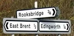
Rooksbridge and East Brent
A rural community in the heart of Somerset dairy country.
 |
Our
village which is part of the parish of East
Brent, sits quietly on the
edge of the Somerset levels, right on the A38 which is a primary route to the
South west.
We are situated about 4 miles. N. of Highbridge,
7 miles. S.E. of Weston super mare and 6 miles S.W. of Cheddar. And within easy
reach of all parts of the South and West.
|
You can find us here on the> Map
|
This milestone on the A38 near Beaconsfield House, remains as a reminder of the important
role of the old Bristol to Exeter Turnpike trust, when Post Coaches and
travellers to all parts of the South west would pass through our village.
|
 |
 |
Before the opening of the M5 motorway,
this tranquil scene --caught during a rare quiet moment-- on the main A38 Trunk road through the village, would not have been the impression many summer visitors to the West Country would have
had of Rooksbridge, as they sat in their cars during the infamous
traffic jams of the 60’s and 70’s!
No need of the Speed Camera in those days.
You would have been sat in a queue!
|
Now that we no longer have places of worship in the village
and sadly our village pub The Wellington Arms, known locally as, 'The Welly' had
closed!
(We
have to nip off to East Brent to satisfy those needs)! (Latest: The
Welly has recently been sold and hopefully will open again soon, hopefully
in August)!
However we can boast that we have
one of those rare facilities. A well stocked local Post Office and Stores. Which
is well used and sells anything from a reel of cotton to the ‘Farmers Weekly’!
And at prices comparable to a supermarket! (Try a 'Happy Shopper'
yoghurt! You'll never taste anything better)!
Although we are a tiny village, we have a wealth of skills and facilities in
Rooksbridge. Many of which can be contacted via the
'Business' link above. But most of all, we have a community spirit and we are pretty
friendly folk!
|
|
|


|
The village of Rooksbridge is now centred around the Post Office and Pub, and the bridge where the A 38 Bristol to Bridgwater road crosses the tiny
Mark-Yeo river, is probably where the village got its name from?
In fact a map of 1575 shows 'rokes bridge', "A bridge over a
river".
In the 5th and 6th Centuries the Mark-Yeo acted as part of a busy thoroughfare
from the small port of Rackley on the river Axe Nr Loxton, across 'ye
Brente marshe'
wetlands
to Glastonbury, where small flat bottom barges carried goods and supplies for the Abbots of Glastonbury etc.
At that time the Abbots of Glastonbury owned and ruled much of the Somerset area we now
live in.
Circa 1995 signs of a medieval wharf were found during river cleaning just
north of York Farm in a field called 'Scott's wharf' at a site where the
Mark-Yeo used to join the old river Axe.
In 1984, traces of a 3rd century roman settlement were
found on land adjoining Pill Row. Sections of a stone wall and pavement,
also remains of a timbered and clay tiled building were uncovered during
drainage work. A full report can be obtained from the
Axbridge Archaeological and Local History Society.
|
|
 |
With its 12th Century Church of St Mary the
Virgin. Its Methodist
Chapel and Primary School, the parish of East Brent also includes the
villages of Rooksbridge and Edingworth. And is bordered by the parishes
of Brent Knoll, Lympsham, Badgeworth and Mark.
According to a land tax assessment made on
22 April 1767. The parish of East Brent was divided into four regions or
tithings, one of which was known as Snighampton? "Rooks Bridge" appears to
have been included in the "Snighampton'' tithing. |
|
Did you
know? |
In
Ashbourne, Derbyshire there are 2 houses side by side, one called “East
Brent” and the other called “Rooksbridge”, which were named by the Wood
family when they returned to Derbyshire in the 1890s.
Andy Wood |
|