


About our parish
See ‘History Group’ for latest meeting notes.
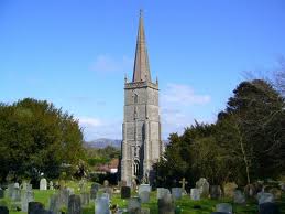
The Parish of East Brent spreads from the lower North eastern slopes of Brent Knoll, overlooked by the magnificent spire of its 13th century church of St Marys
on the edge of the Somerset Levels.
The parish also includes the village of Rooksbridge and the hamlet of Edingworth.
Apart from the well documented history of the Knoll itself....
East Brent and its satellite villages have much to offer regarding interesting finds of recorded and unrecorded history of the people and places that we hope bring together here.
Some History
Welcome to the parish of East Brent
The parish church of St Mary the Virgin.
It also includes the village of Rooksbridge and the hamlet of Edingworth.
Situated about 4 miles. N. of Highbridge, 7 miles. S.E. of Weston super mare and 6 miles S.W. of Cheddar on the A38 which is a primary route to the south and west.
The M5 motorway also passes through our village which puts us within easy reach of all parts of the South, West and the Midlands.
One of East Brent’s claims to fame, was the founding by the Rev. Denison and local farmers of the first ‘Harvest Home’ celebrations in the 1850’s. Similar celebrations have spread to many rural communities around the countryside.
Over the centuries, the area’s primary industry has been agriculture, dairying farming being the general occupation.
A dairy was founded in the 1860’s to process the milk, by local farmers Arney, Clothier and Wood was located in Rooksbridge and operated until 1993.

This milestone on the A38 near Beaconsfield House, remains as a reminder of the important role of the old Bristol to Exeter Turnpike trust, when Post Coaches and travellers to all parts of the South west would pass through our village.
 In 1984, traces of a 3rd century roman settlement were found on land adjoining Pill Row.
 Sections of a stone wall and pavement, also remains of a timbered and clay tiled building were uncovered during drainage work.
A full report can be obtained from the
Axbridge Archaeological and Local History Society.
According to 1670 Hearth Tax assessments, the parish of East Brent was divided into four regions or tithings:
Snighampton, Eddingwurth, Burton and Sislinghampton?
"Rooks Bridge" appears to have been included in the "Snighampton'' tithing.
Did you know?
In Ashbourne, Derbyshire there are 2 houses side by side, one called “East Brent” and the other called “Rooksbridge”, which were named by the Wood family when they returned to Derbyshire in the 1890s.
“Andy Wood”
Abbot John Selwood of Glastonbury built a mansion in the village in the 15th century, which was demolished in 1708.
In 1851 George Anthony Denison was preferred to the valuable living of East Brent, and in the same year was made Archdeacon of Taunton. He was responsible for establishing the annual Harvest Home festival in the village.
From Wikipedia
Hundred (county subdivision)
A hundred is a geographic division formerly used in England, Wales, which historically was used to divide a larger region into smaller administrative divisions. Alternative names include wapentake
In England and Wales a hundred was the division of a shire for administrative, military and judicial purposes under the common law.
Originally, when introduced by the Saxons between 613 and 1017, a hundred had enough land to sustain approximately one hundred households
Appeal
Seeking information about the men of East Brent who served in World War One.
2014 is the centenary of the declaration of WW1. We would like to commemorate the 80 or so men from east Brent parish who served in the conflict.
Did your East Brent relative serve or do you know anyone who may have a family relative who served in the conflict.
We are also looking for the stories of the later lives of those men who returned.
Any information, copies of photos, service records and memorabilia would be greatly appreciated.
Please contact; John Rigarlsford at jonrig@rooksbridge.org.uk Thank you!
| William's letters home |
| Bessies Poems |
| Edwards Letters Home |
| Cheddar Valley Dairy |
| EBPC Archives |
| Methodist |
| Rooksbridge baptist chapel |
| Shops & Tradesmen |
| Rooksbridge Post Office |
| St Marys |
| Village pump |
| War memorial |
| Wellington Arms |
| Workhouse |
| A day at the dairy |
| vicars |
| WardensAcc |
| deanery mag |
| WW1 Exhibit |
| Workhouse Life |
| War Memorial |
| Cheddar valley Dairy |